

Garmin GPSMap67 Series Review
Are you are looking for a robust four-season handheld GPS device with excellent battery life, detailed mapping & also options for emergency communication when out of mobile phone coverage, for your Hikes, Walks, Trail Runs.
The Garmin GPSMap67 series was released in March 2023 as a replacement to the very popular GPSMap66 series, since its launch it has become our most popular handheld GPS device for Hikers, Walkers & Trail Runners.
Garmin GPSMap67 Series New Features/ benefits added since the GPSMap66 Series
NEW - Multi-Band GNSS Support – Access multiple navigation Satellites (GPS, Galileo and QZSS) Get access to multiple frequencies sent by navigation satellites for improved position accuracy where GNSS signals are reflected, weak or typically don’t penetrate.
NEW – Improved Battery Life – With the previous GPSMap66 series the GPSMap66s & 66st were powered from AA batteries and the GPSMap66i / 66sr models from a built-in Lithium rechargeable battery.
Both the new GPSMap67 & the GPSMap67i inReach version are powered by a built-in lithium battery, with improved technology the battery capability has increased greatly since the GPSMap66 series, giving us up to 5 x more battery life.
GPSMap67 - an impressive battery life of up to 180 hours in GPS Mode & up to 840 hours in expedition mode.
GPSMap67i - an impressive battery life of up to 165 hours in tracking mode & up to 425 hours in expedition mode.
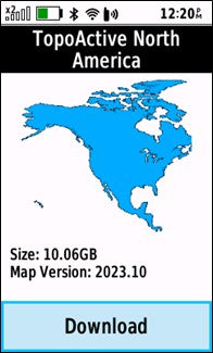
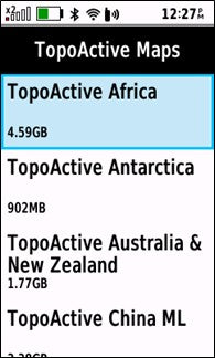
NEW – Update pre-loaded Maps via Wi-Fi - The pre-loaded Topo Active European Maps can now be updated via Wi-Fi rather than using Garmin Express software on a computer, there are now also options to download Garmin Topo Active Maps for regions out of Europe using Wi-Fi directly on the unit for free.
Currently the list of Maps that you can download include: Africa, Antarctica, Australia & New Zealand, China ML, Greenland, Hong Kong & Macao, Japan, Korea, Middle East & Central Asia, North America, SGMYVNPH (Singapore, Malaysia, Brunei, Vietnam, and Philippines), South America, Taiwan, & THID ((Thailand and Indonesia)
Why choose the GPSMap67 series device, what is it like to use, our own personal experiences.
Why I chose the GPSMap67i for my own personal device
I have been using a GPSMap67i device since its launch in March 2023 and have been very impressed with the device for both navigating with and using the inReach messaging / tracking services.
I went for the GPSMap67i version with full GB Ordnance Survey 1:25k Mapping, the ‘i’ denotes the inReach version with two-way satellite messaging the SOS button.
*Monthly subscription is required for inReach services.
Personally I spend a lot of time in the hills hiking & trail running in areas with very limited mobile phone connection and I am often out on my own, for peace of mind I went for the inReach version of the GPSMap67 series, otherwise other than the inReach two-way Satellite messaging & SOS button using Satellites the device is the same as the standard GPSMap67 without the ‘i’.
I also take part in ultra-events such as the Montane Spine Challenger, with the event potentially taking up to 60 hours, selecting a device with great battery life was important, knowing that I would not need to worry about charging it.
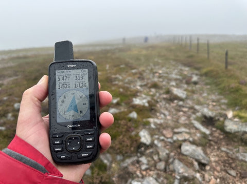
With the GPSMap67 series being a push-button unit, using it in all seasons & weather is not an issue, I walk and trail-run all year round and like that I can use the GPSMap67 with my gloves on , with a weather rating of IPX7 & tested to military standards for thermal, shock & water performance (MIL-STD-810) a tough robust unit that is not too bulky, the slim style sits nicely in the hand.
The 3” colour screen of the GPSMap67 series unlike my mobile phone is sunlight readable, and for nighttime navigation the screen has an adjustable backlight brightness, but when using a headtorch the screen really lights up with the backlight set low & the buttons themselves are slightly back-lit.
Mapping
We stock the GPSMap67 series devices with the pre-loaded Garmin Topo Active European Maps but also have options of adding a full GB Ordnance Survey 1:50k Landranger or the more detailed 1:25k Explorer Map Card to the device.
I personally went for the more detailed Ordnance Survey 1:25k Maps as I do like to see the extra detail of field boundaries , especially when walking and running trails that are not as well marked


OS 1:25k Scale OS 1:50k Scale Garmin TopoActive
We have a great article here – Do you need OS maps on a Garmin GPS Device
Sending Routes to the GPSMap67 Series / navigating with your device
You can simply use the GPSMap67 device to see yourself move across the map with no route loaded, but I personally find sending a pre-planned route to the device really helps with the whole navigational experience, also if you are taking part in events such as the Montane Spine etc, they will often provide you with a GPX Route / track file that can be loaded onto your GPS Device.
I really like that with the GPSMap67 series you have several flexible options on how to get your pre-planned routes or supplied GPX files on to the device.
On a Windows or Mac computer you can use the more traditional method of Garmin’s free route planning software called Basecamp, with your GPS device connected to your computer you can plan routes using whatever mapping you purchased with your device, with the maps being read directly from your device you do not need an internet connection.
You can also import GPX Route / Track files into Basecamp software to send to your device.
If you do not own a computer or would prefer to use a mobile device, you can also transfer GPX routes / tracks from your mobile device by either using the Garmin Explore mapping app or the Garmin connect app.
You can use other mapping apps to plan on, I use our own GPS training Ordnance Survey Route planner for planning in Great Britain, there is no charge to use this route planner and you can plan on either a OS 1:50k or the more detailed OS 1:25k Map.
More information on our Free OS Planner here

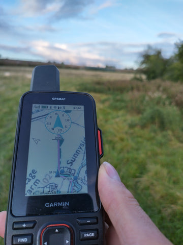
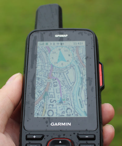
With a Route open on your GPSMap67 device rather than just seeing yourself move across a map you also have a magenta line displayed on top of your map to help guide you along your route. your current position is show as the Blue Triangle Pointer and moves across the map as you move.
You can also add a compass bezel to the top of the map screen, this then displays a pointer with the direction of travel that you need to take to get to the next via point on your route.
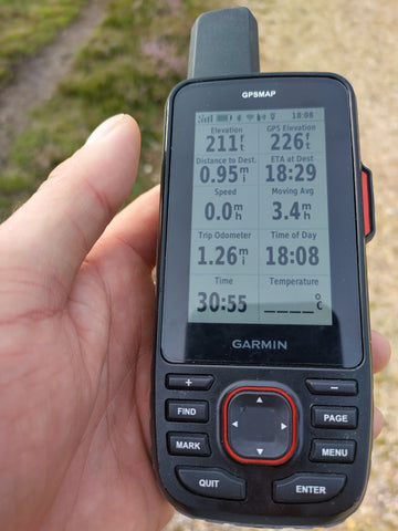
Another advantage with a route loaded is that you can view useful information on the trip computer screen data boxes, such as Distance to end, Estimated time of arrival, ascent & descent etc.
You can change the data boxes to many different choices to personalize the type of information that you would like to see.
More info on the Data Field options available here
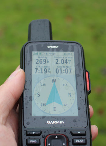
The GPSMap67 series has a 3-axis electronic compass, this means that even when you are stationary and with the map screen set to track up, as you turn the device the map turns with you showing your direction of travel.
When you are navigating with a Route loaded on your device, you can easily swap between the map screen to a large compass bezel showing a large clear pointer, which points you in the direction of travel to the next point on your route.

Accuracy
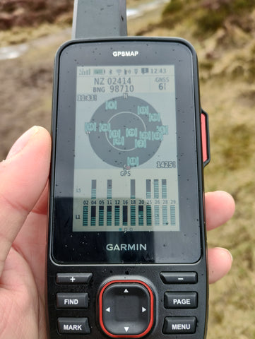
With the new Multi Band Dual Frequency GNSS Chip I have found the accuracy of the GPSMap67 to be excellent, from the picture below of the satellite page you can see an accuracy of 6 feet.
The Satellite screen is also very useful as it also displays your current grid reference, which you can then cross refer with your paper map.
Elevation Data
One other feature that I really find useful is when following a Route you can display an elevation graph showing where you have been and what climbs are coming up as per the picture below.
The GPS Device itself also has a Barometric Altimeter to record and show you accurate height data.

Trackback function
When you start an activity recording on your GPSMap67, at any time you can select an option to Trackback to the start of your activity.
A breadcrumb trail of your recording to navigate back along is then displayed as a Magenta track line on the map screen of your GPSMap67, you can also select the compass screen to display a large pointer showing the direction of travel you need to go into to follow back along your recorded track points.
Using the inReach Two-Way Satellite communication features of the GPSMap67i
One of my own personal reasons for choosing the inReach version of the GPSMap67 was to give me piece of mind as I am often walking & running trails in areas with very limited mobile signal.
This is a subscription based service starting at £12.95 a month for an annual subscription.
Although I have not needed to use the SOS button for help I have found the two-way satellite messaging & tracking function invaluable and a great way to keep in touch with family & friends when out in the hills and knowing if I was to have an accident or come across someone else needing help that I would be able to summons emergencies services using the SOS button.
All family & friends need to do to be able to reply to your messages is download the free and simple to use Garmin Messenger App and they are ready to go.
The inReach subscription services on the GPSMap67i give you the following features to use when out of mobile coverage using the Iridium Satellite system whether on land or sea.
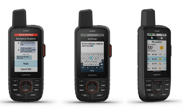
- In emergency trigger an SOS alert:
In case of emergency, trigger an interactive SOS message to GEOS, the Garmin-powered International Emergency Response Coordination Center (IERCC) with professional 24/7 global monitoring. Trained staff are available to respond to your messages, track your device and notify emergency responders in your area - giving you the peace of mind that help is on the way. The Garmin IERCC will stay in touch with you and your emergency contacts until your situation is resolved.
We have great article with an example of what happens when you press the SOS button – More info here
- Send friends & family a quick pre-set check-in message to let them know that you are okay:
This is a very useful function that I use to let family & friends know all is okay, there are 3 x pre-set message that you can simply select from the device itself as follows – I’m checking in everything is okay, I’m starting my trip & I’m ending my trip.
You pre-set who these messages go to, they do not come of your monthly message allowance hence with a active subscription package you can send as many of these messages as you want, a useful feature is you can set your location to be included so friends and family receiving the message know where you are when it was sent.
- Send friends & family a typed message / Short preset text:
You can type a message directly on your unit to send to friends and family, with the button control of the unit this can take a bit longer to type when we are so used to touch screen devices, you can using the Garmin Messenger app on a smart phone type your message on your phone but with your phone paired with the GPSMap67i device if you have no mobile signal the message will be sent via the iridium satellite system, I found this a great way of getting in touch with family when out of mobile coverage and also useful if you need some help but not requiring emergency services etc.
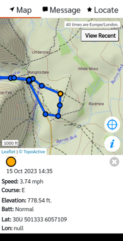
- Map Share your live location with inReach Tracking:
You first create a Garmin MapShare web address link, you can then simply share this link with family & friends, if you start inReach tracking on your device, friends and family can simply open your MapShare address, they will then be able to see your movements across a map.
N.B. If you are on the Safety package which starts at £12.95 a month you are charged £0.10p per track point, I personally use the tracking function a lot when on my long-distance trail running events etc, hence I have opted to pay for the next package up the recreation package at £24.99 a month.
You can set the inReach tracking intervals from 10 minutes, 20 minutes, 30 minutes, 1 Hour, 2 Hours & 4 Hours intervals, I have been using 10-minute tracking which is why I opted for the £24.99 package as when I am taking part in long multiple day events, I do not need to worry about additional charges for track points.
- Live weather data received via the Satellites.
You can use inReach connectivity to get detailed weather updates on the GPSMAP 67i handheld GPS. Request weather forecasts for your current location, waypoints, or destinations on your route.
*Weather data received via Satellite does use some of your message allowance as shown on the subscription information, but a great way to get up to date weather information when you are off grid with no mobile data.
We have more information on the subscription options available on the GPSMap67i product page and under the FAQ’ tab – Product page here
N.B. If you purchase a GPSMap67i device you do not have to sign up and subscribe to the inReach services to use the device as you would the none inReach version, but you will need an active inReach subscription to use any of the inReach features that we mentioned above including SOS, check-in messages etc.
There are also flexible packages that you can run on a month-to-month basis rather than signing up for a year and then suspend when not being used starting from £14.99 a month.
As well as initiating an SOS, sending a check-in or typed message directly from the unit, these functions can all also be done via the Garmin Messenger app on your mobile phone paired with the device.
The Garmin messenger app has a nice feature that if you do have mobile phone signal when sending or receiving a text message the messenger app will send & receive them via your mobile data into the app, this is a great function to keep your Satellite messages down from you monthly subscription allowance.
This also means that if you were to turn your device off, say in the evening when you are at some accommodation where you have a mobile signal, if friends & family message you via the Garmin Messenger app you will still receive the messages on the app and can also reply back via the app, so that you never miss a message.
Our Conclusion
Having used my own GPSMAp67i device now for the last 8 months, I cannot fault the device on what I have been using it for, it has helped me the last year navigate on some tough challenges in all weathers including the Montane Spine Challenger ultra event.
The battery live has impressed me so much, Garmin quote figures of up to 165hrs with GPS only, Battery life will be affected by how many times you bring the screen on, backlight settings, temperature and GPS setting.
I have my own unit set on Multi GNSS Dual Frequency / Multi Band which I know will use more battery than just GPS only, but I love the accuracy of the multi-band and speed of satellite lock, but even with this setting and using the device in some very cold wintery conditions with the screen on more than normal I have still achieved battery life of well over 120 hrs taking in to account all of these factors.
Accuracy in challenging environments such as dense tree coverage, deep ravines with high sides etc has been very impressive, I have my own unit set to the Muli GNSS / Multi Band and often see accuracy down to approx. 6 – 8 feet, the device is also very quick in locking onto satellites from a cold start.
The slim style of the unit and weight of 241g is ideal for me carrying on Hikes, Trail runs etc, it is not bulky and feels comfortable in the hand, it can be easily carried in the front narrow pockets of my backpack but also just as easy to attach to my backpack using the Garmin backpack tether, the backpack tether does ensure that I do not accidently put my device down and leave it behind, as it is tethered to your backpack.
I know that we are all so used to touch screens with our phones, but the button control works well for me and suits my all-season activities, especially when wearing gloves in the winter, I have had the screen & buttons on my device covered in mud, water etc but had no issues using the buttons to navigate between screens, move around on the map etc.
For hiking & trail running all season and with the extra peace of mind of the inReach Two-Way Satellite communication functions, battery life, accuracy & ruggedness this is my go-to unit of choice.
With a purchase of a GPS Device from GPS training our Gold Support package worth £145.00 is included, as well as email & telephone support our Gold Support package also includes access to all our Online training videos to get you to grips with your eTrex SE device & Garmin Explore App.
Further reading
1. For more information on the GPSMap67 - More info here
2. For more information on the GPSMap67i – More info here
3. Walk and talk - Garmin GPSMAP67
3. Video - 5 most asked questions - Garmin GPSMAP67